Well, the day of severe weather is upon us. And it's now around 4:30 PM central time and we're still waiting for storms to fire.
In my last post, I talked about how a feature called the "capping inversion" would work to inhibit thunderstorm development throughout the afternoon until this cap could be broken so that air could more easily rise. Remember that the capping inversion can be seen as an area where the temperature warms with height instead of cooling with height like usual.
So how did today start out? First let's look at the sounding from 12Z this morning (around 7 AM CDT) at Norman, OK:
 |
| Fig 1 -- OUN sounding from 12Z, April 3, 2011. From the SPC website. |
In these soundings from the SPC website (which are packed with lots of useful and fun information), the sounding profile, which shows temperature and dewpoint as they change with height, is in the upper-left panel. We can see that this morning in Norman a very strong capping inversion was in place. The temperature at the surface was 69 degrees Fahrenheit. The temperature starts cooling with height, but then the temperature abruptly rises right around 850mb. Above this level, the temperature begins cooling again. So we see that there is a capping inversion (a "cap") in place around 850mb. This prevents warm, moist air (the dewpoint at the surface was 64 degrees at this time) from rising out of the surface layer. There is a lot of convective potential--the most unstable CAPE value for this sounding (MUCAPE) is at 2025 J/kg--definitely enough for severe weather. However, with the cap in place, it's difficult to tap into that energy unless a front comes through or the cap can erode.
Topeka, Kansas, (which is further north) had a similar-looking sounding this morning:
 |
| Fig 1 -- TOP sounding from 12Z, April 3, 2011. From the SPC website. |
We see a similar capping inversion right around 850 mb. The air in Topeka also had a high convective potential with a MUCAPE value of 3019 J/kg. But that capping inversion, once again, is keeping a lid on the convection. Remember, these soundings were at 12Z, or around 7 AM local time. This means the sun had only just come up in these areas. As I mentioned in my last post, because the ground cools overnight (assuming there are relatively clear skies), the air near the ground also cools while the air above that stays warm, helping to re-generate and maintain this capping inversion. But, during the day, the surface temperature can warm up--sometimes drastically. We can also see small-scale convective and turbulent mixing work to "mix out" the capping inversion. So--has any of this happened yet today?
It just so happens that both Norman and Topeka launched special soundings at 20Z, or 3 PM central time. First, here's Norman's mid-afternoon sounding:
 |
| Fig 3 -- OUN sounding from 20Z, April 3, 2011. From the SPC website. |
Things have changed quite a bit, but one thing hasn't--there's still a pronounced capping inversion at just above 850 mb. Other than that inversion, the atmosphere is very unstable. The lapse rate (the rate at which temperature changes with height) below the capping inversion is practically dry-adiabatic--the most unstable lapse rate you can get (before the atmosphere automatically convects on itself). Note that the dewpoint temperature at the surface, however, has dropped a bit--it used to be 64 degrees and now it's down to 61 degrees. The winds are still out of the south at the surface, so we can be pretty sure that the dryline has not moved through yet. We can confirm this by looking at a dewpoint map of Oklahoma from the Oklahoma Mesonet:
 |
| Fig 4 -- Dewpoint temperatures from the Oklahoma Mesonet at 430PM, CDT, April 3, 2011. From the Oklahoma Mesonet. |
The dryline is clearly visible as the separation between the humid air to the east and the much drier air to the west. This image is from a whole hour and a half after the above sounding was launched, so even now the dryline still has not made it to Norman (which is right about in the middle of the state). However, in the above dewpoint map we can see that the dewpoint in Norman is now down to 58 degrees. We still have southerly winds, so that should be advecting in more moisture. Why is the dewpoint going down?
Remember I mentioned before that one way to try and erode away the cap was for turbulent and small-scale convective turbulence to "mix out" the sharp temperature rise at the level of the cap. This turbulent mixing does other things too. In this case, it's helping to bring much drier air aloft down to the surface. Notice on Norman's mid-afternoon how the dewpoint temperature drops off considerably above the level of the capping inversion. As turbulent mixing goes on trying to even out that temperature change at the cap, some of that very dry air just above the cap is mixed down below the capping inversion and into the surface-layers of the atmosphere. By mixing in this drier air, the dewpoint temperature of the air near the surface actually decreases. So, the fact that the dewpoint temperature at the surface has been decreasing during the day is actually proof that this turbulent and small-scale convective mixing is really going on. However, it has not been enough so far to significantly weaken the capping inversion so storms can grow.
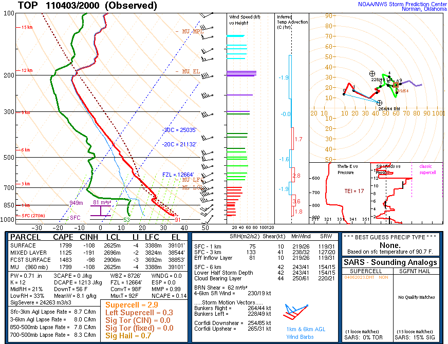
However, let's take a look at the mid-afternoon sounding from Topeka:
 |
| Fig 5 -- TOP sounding from 20Z, April 3, 2011. From the SPC website. |
Note that their dewpoint has also dropped since this morning--it was 56 degrees and now it has dropped to 53 degrees. So, we can assume that similar kinds of mixing went on over Topeka. However, in this case the surface temperature has warmed up extraordinarily--from 65 degrees in the morning to 91 at the time this sounding was taken. The winds seem to be shifting more southwesterly at the surface, but the latest surface maps (not shown) show it still to be ahead of the advancing cold front. More importantly, though, see what has happened to the capping inversion. It's practically non-existent now! In this case the mixing seems to have been enough to erode away most of that capping inversion, and we're left with very steep lapse rates (temperatures cooling off rapidly with height--rather unstable). However, all that mixing that went on to erode the cap did bring down drier air from aloft like we saw in Norman, As such, the surface moisture is somewhat weak--the dewpoint is in the low 50s. However, in northern and central Missouri right now, temperatures are in the upper 80s and low 90s, but the dewpoint are in the mid 60s. With similar surface temperatures to Topeka but with more moisture, we might guess that in much of northern and central Missouri right now, the cap may have been significantly weakened, but more moisture was left at the surface to work with. As such, the potential is much higher for severe storms to form ahead of any fronts coming through in this region.
So...in summary. This morning, like we expected, a strong capping inversion existed over the southern plains and into the midwest. By this afternoon, a lot of vertical mixing has taken place. In Oklahoma, the mixing has not been enough to really erode the cap very much, and as such they're probably going to have to wait for the dryline to mix through or for the cold front to swing down to provide enough lift to push air through the cap and see storms. However, further north in eastern Kansas and northern and central Missouri, the Topeka sounding seems to indicate that the capping inversion has mostly eroded by late this afternoon. This will make it much easier for storms to form, even before the cold front swings through with its strong lift. Since storms forming out ahead of a front in the warm, moist sector can be surface-based, the potential for tornadoes and large hail producing storms is higher here with any storms that do fire off before the front comes through. This is part of the reason why the SPC's current moderate risk of severe storms is right in the region I just outlined:
 |
| Fig 6 -- SPC Day One Convective Outlook issued 20Z, April 3, 2011. From the SPC website. |
However, regardless of what happens in the next few hours, the cold front will sweep through the area tonight. The lift provided by the front will most likely cause lines of storms to march across the entire region tonight. However, these storms will probably be elevated because they are both caused by the front and they will be occurring after dark, giving the capping inversion time to re-generate. Nevertheless, hail and strong winds will still be a threat.
Still waiting...and watching.


No comments:
Post a Comment