Well, with a new year I decided it was time for me to resume my blogging activities. So, I'll try to have regular updates on a weekly/biweekly basis at least as new weather topics come to me.
On Sunday afternoon, January 18th, most people in the Puget Sound area were glued to the television to watch the Seahawks game. Passing outside their windows was a series of strong showers following a cold front, not at all unusual for the mid winter here. Just before 2:30 PM PST the National Weather Service started getting reports of a tornado near Gig Harbor, Washington. Here is the 0.5 degree base reflectivity radar image from the time. Several strong, but compact cells across the southern Puget Sound lowlands. Nothing that screams "tornado"...
It wasn't even the most intense cell that ended up attracting the attention here. That cell produced hail later on, though at the sub-severe level. No, it was the little blip to the west that produced an EF-1 tornado on the southeastern Kitsap Peninsula. Here's the National Weather Service Seattle WFO storm survey results:
We joke about some of the storm damage markers we get from tornadoes in western Washington. "Skylight cover sucked off". "Kayaks moved around." Though it's too bad that all tornadoes can't be this tame.
This has gotten me thinking about tornadoes in western Washington. We get a few episodes with waterspouts every year, but tornadoes themselves are not very common. I went back to the
Storm Prediction Center's Severe Weather Database that I used in a
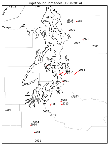
previous blog post. This includes a record of all known tornadoes since 1950. It turns out in Washington state west of the Cascade Crest there have been 46 tornadoes since 1950 (47 after Sunday's event). Here's a map of the tornadoes in the immediate Puget Sound area, labeled by year:
Those without red dots had path lengths too short to show up. Given the short paths, relatively weak strength and the large amount of rural/undeveloped area in this region, there are probably more that escaped detection. But there are actually more than I thought there would have been.
Another unusual feature of these tornadoes in the seasonal climatology. Here is a histogram of the number of tornadoes per month (sample size of 46).
There's an odd sort of bimodal distribution here, with a rapid increase in number from March through June, then NONE in July, followed by a secondary ramp up in the fall through November before none in December and February. Granted, this is a small sample size, but it's interesting that the tornado probability seems to crash so rapidly at the end of Spring and Fall.


No comments:
Post a Comment