

According to the Houston forecast office, they're expecting 1-3" on average for most of their forecast area with locally heavier amounts up to 5" today. That's a lot of rain, particularly for an area that still is in a large precipitation deficit. Here's the latest national drought monitor image (from January 3rd, released January 5th):
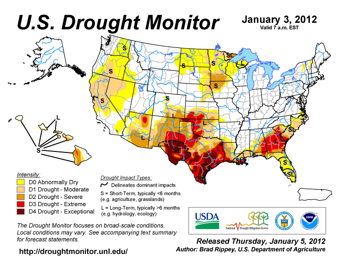
Much of Texas, particularly south Texas, and parts of Oklahoma are still in "extreme" to "exceptional" drought. Hopefully today's rains will help alleviate some of that...
Let's look at how the upper-air pattern is going to change over the next few days. Here's the current 500mb picture from this morning's GFS analysis:


However, notice that there's a shortwave trough that's beginning to dig in from up in Canada. In this 48-hour forecast the trough is centered over southern Manitoba back through Eastern Montana. This trough is forecast to deepen pretty significantly over the following 48 hours. The little cut-off low in the south is forecast to move up the east coast, helping to bring in warm air from out over the Gulf Stream. As the shortwave trough digging in from Canada in the above image moves eastward, it's going to encounter the rather strong baroclinic zone (warm-cold temperature gradient) left behind by the little cut-off low over the east coast. Remember that upper-level winds are strengthened by strong horizontal temperature gradients below. As such, that shortwave trough really starts getting strong by Friday morning:

But notice what is happening to the overall upper-air pattern--a strong ridge is building over the west coast, while large-scale troughing is occurring over most of the US east of the Rockies. This would be considered the longwave pattern, as opposed to the shortwaves we usually talk about. Shortwaves are the smaller troughs embedded in the bigger, longwave pattern. Here the longwave pattern has shifted to ridging over the east Pacific and troughing over the central US. This is actually a very typical La Nina type of upper-air pattern.
And if we're getting into a typical La Nina type pattern, all of those long-term weather predictions about the type of winter to expect should start coming into line. The pattern is forecast to become even more established by Saturday:


No comments:
Post a Comment