

In the east, particularly the northeast, you can see a lot of places where the high temperature in the past month has been in the lowest 1-3 percentile of the past 30 years. The cold continues out in the midwest and southeast where the average high temperature has been in the 15-20% range of normal high temperatures.
Contrast this with the west, particuarly west of the Rockies. Incredible warmth out here! Many pleases are in the 99th percentile for high temperatures over the past month. Extremely warm.
We can see this in the large scale pattern as well. Here are the 90-day (three month) anomalies of 500 hPa heights over the Northern Hemisphere:

There has been a very persistent pattern over the past few months; rarely do you have such large anomalies that show up in the 90-day climatology. Notice the pattern---anomalously low heights (associated with troughing and often colder air) in the central Pacific, anomalously high heights (associated with ridging and often warmer air) over the western US and up into Alaska, followed by another belt of lower heights over northeastern Canada and slightly into the eastern US, and then another area of high heights in the central Atlantic. This means that the atmosphere has had persistent ridging over the west. This ridging has acted like a protective shield, deflecting significant storms and cold air outbreaks to the east. No wonder it has been so warm and pleasant in Seattle this winter...
This pattern of alternating troughs and ridges arcing across North America is something that is called a Rossby wave train and this particular pattern is known as the Pacific-North American pattern (PNA). The PNA pattern is suspected to be caused by variations in heating along the equator. Here's an example of what the PNA pattern is supposed to look like during the winter of a strong El Nino year:

This looks a fair bit like our anomaly pattern above, though our exact pattern is shifted a little further south and west. Because our current pattern is rather similar to this classical PNA pattern, we would say that the current pattern projects strongly on the PNA. We can measure the correlation between the upper-level pattern of ridges and troughs every day with the classic PNA pattern. Here's a time series of what that has looked like over the past few months from the Climate Prediction Center:

The more closely the current pattern matches the PNA pattern, the more positive the index here. We can see that, at least since mid-December, this PNA index has been slightly positive for the most part. Remember that the cannonical PNA pattern in the map above is most prominent during El Nino periods. Despite some signs last year that an El Nino was going to develop, we have not developed a strong El Nino this winter. Here's the Nino 3.4 index over the past two years:
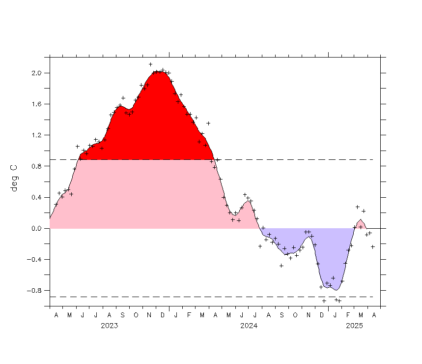
You can see that though we've been in a weakly positive (El Nino) phase for much of 2014 and into 2015, the values have not gotten up to 1.0 yet, which is a commonly-used threshold for declaring an El Nino event.
So we've been stuck in an "almost" pattern for the past several months---a weak El Nino and a weak PNA pattern. Notice, however, in the plot of the PNA index above that there are several red lines extending into March that represent different long-range forecasts of the PNA index. Notice that most of the forecasts are actually predicting a significant swing into a negative PNA phase. This would mean that the pattern is more like the opposite of the PNA: more troughing in the west and ridging in the east. Our longer-range weather forecasts are also hinting at this. So, we may finally be getting out of this rut...
No comments:
Post a Comment