

We can see that extraordinary swath of snow that the most recent set of storms this weekend has brought to the mid-Mississippi and the Ohio River Valley---much further south than the snow we've seen so far this season. North of that, repeated rounds of storms have brought a lot of snow to the upper midwest and the mid-Atlantic and New England. But in between them is a narrow sliver---from southern Iowa through central Illinois and Indiana and into Ohio---between the two snowy areas. You can see that area on the visible satellite this morning over central Illinois:
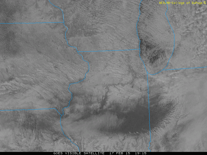
There are clouds developing to the east over central Indiana, but there is a clear gap in central Illinois between the northern snowpack and the southern snowpack.
Springfield, Illinois happens to sit in that gap. Springfield also happens to be the current forecast city for the national WxChallenge forecast competition. Nearly everyone (including most of the models) thought that the clouds would stick around today and keep the sun out. Furthermore, it's unclear whether our weather models actually started out thinking there was snow on the ground in this region. For one or both of these reasons, the high temperature today was forecast to be between 20-22 Fahrenheit. It's already up to 30.
The SPC Mesoanalysis shows a clear pocket of 25-30 Fahrenheit temperatures (the purple contours) over central Illinois in this "gap" in the snowpack:

It's pretty amazing how much having snow on the ground keeps down the temperatures, even in broad sunlight. Much of it has to do with the albedo of snow versus bare ground. Snow, being white, has a higher albedo, meaning it reflects more of the incoming solar radiation. Bare ground, on the other hand, tends to be much darker in color and therefore has a lower albedo, meaning it absorbs more solar radiation and has a tendency to warm up because of that. These simple differences in the color of the surface can make a world of difference when it comes to temperature.
We can look at this morning's sounding from Lincoln, IL, just to the northeast of Springfield to see what the temperature profile looked like:
.gif)
There's a pretty sharp inversion just above 850 hPa. This actually leaves a pretty deep layer below that over which a lot of mixing has to have taken place for the temperature to warm up to nearly 0 Celsius. Furthermore, if the sunshine continues and we don't have clouds move in (which we may see soon from the west), following a dry adiabat down from that inversion suggests that if it completely mixes out, it could get as high as 3-4 Celsius (37-39 Fahrenheit). However, it's already mid afternoon there, clouds may move in shortly, and there is a fairly brisk northwesterly wind that's helping to advect in cooler air from off the snowpack to the northwest. It has still gotten up to 34 Fahrenheit at some surrounding coop sites...
Anyhow, an interesting case of how small-scale variations in the snow can have big implications for the temperature.
No comments:
Post a Comment